Storm Babet set to batter Sunderland with heavy rain and 50mph winds
and live on Freeview channel 276
Households in Sunderland may have found themselves awoken by strong winds tearing at their homes through the night.
But the worst of Storm Babet is yet to hit Sunderland.
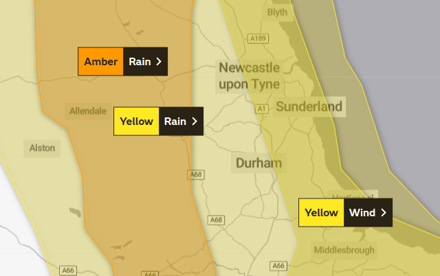
A yellow weather warning for heavy rain is in place for the city from 6pm tonight (Thursday, October 19), lasting until 6am on Saturday, October 21.
Advertisement
Hide AdAdvertisement
Hide AdAnd a yellow weather warning for strong winds is also in place, lasting from 12pm on Friday to 12pm on Saturday.

Experts at the Met Office are warning of potential disruption and urging people to stay safe.
Sunderland City Council has already cancelled Thursday's running of the Festival of Light in Mowbray Park, with decisions due on whether the event will go ahead on Friday and Saturday.
When the rain will hit Sunderland
The rain is due to begin in Sunderland at 12pm today, starting fairly light but becoming heavy around 3pm, then easing off with drier spells between 6pm and 8pm.
Advertisement
Hide AdAdvertisement
Hide AdThe rain is forecast to begin again at 9pm, however, turning heavy at 10pm.
Friday will see persistent and mainly heavy rain all day, according to the forecast, and it isn't due to ease off until mid-morning on Saturday, though the weather will remain wet until late Saturday night.
Sunday is forecast to be drier.
When strong winds will hit Sunderland and the North East
It will remain windy for much of Thursday, and tonight will see speeds building to around 40mph.
Comment Guidelines
National World encourages reader discussion on our stories. User feedback, insights and back-and-forth exchanges add a rich layer of context to reporting. Please review our Community Guidelines before commenting.