Temperatures to head below zero as 15ft waves predicted for Sunderland coastline in coming days
and live on Freeview channel 276
Areas of the North East woke today, Monday, April 5, to a sprinkling of sleet, with further cold weather on its way.
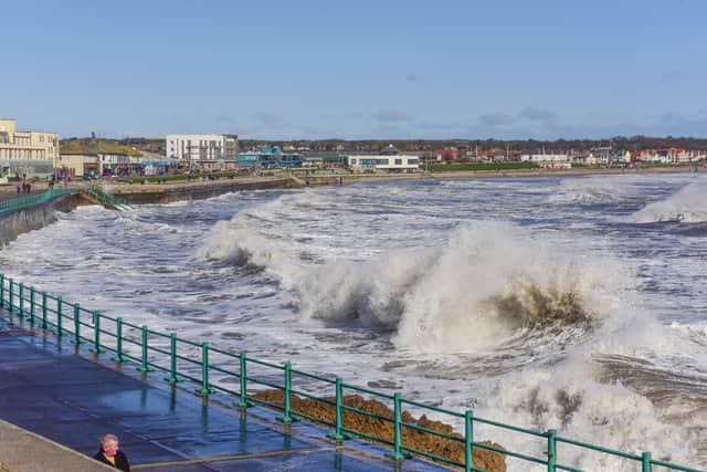
It comes as waves as high as 10ft are expected to hit our coast today, with our photos taken earlier today showing how rough sea conditions are already being experienced on our seafront.
Advertisement
Hide AdAdvertisement
Hide AdThey are expected to rise to 14ft tomorrow, Tuesday, April 6, and then as high as 15ft in the early hours of Wednesday, April 7.

This is what the Met Office says we can expect from the weather.
What is predicted for later today?
Forecasters say we could see more snow showers during the afternoon, most likely along the coastal areas of the region.
The warmest it will get is 6C around mid-afternoon, but windy conditions will mean it will feel as cold as 1C and as low as -3C this evening.
Advertisement
Hide AdAdvertisement
Hide AdDuring the night, we can expect a dry and clear night, although it is possible we will see more snow showers.
The winds will remain strong and we could see a widespread frost in the evening.
What can we expect tomorrow?
On Tuesday it will be another cold day, with sunny spells but a greater chance of snow showers.
The winds will remain strong we’ll see a widespread frost overnight.
Advertisement
Hide AdAdvertisement
Hide AdThe maximum temperature will be 4C around early afternoon, but it will feel as cold as -4C during mid-morning.
How about the longer outlook?
From Wednesday to Friday, April 9, the Met Office says it will be less cold and windy on Wednesday but cloudier, with some rain overnight.
It will be windy and milder on Thursday, with rain at times and then colder again on Friday, with further wintry showers.
Will the cold weather continue?
The outlook for Friday, April 9, to Sunday, April 18, suggests it will be a period of more settled conditions again giving way to another cold and wintry picture, especially for northern areas.
Advertisement
Hide AdAdvertisement
Hide AdWithin this a mixture of sunny spells and showers remains likely and some outbreaks may be wintry, especially in the north, with strong winds expected.
After this, conditions are likely be drier and more settled for most.