Sunderland from the sky: Historic England launches online map of old aerial photos including Wearside and Seaham
and live on Freeview channel 276
The platform allows people immediate digital access to Historic England’s nationally-important collection of aerial photographs.
Over 400,000 images from 1919 to the present day have been added to the tool, covering nearly 30% (c.15,000 square miles) of England, including major areas of the North East.
Advertisement
Hide AdAdvertisement
Hide AdImages from the region include aerial photographs of St James’ Park Football Stadium in Newcastle taken in 1927, ancient archaeology in Northumberland, industrial heritage in Sunderland and Middlesbrough, and the coastline at Seaham Harbour in County Durham and Saltburn, Teesside.

Aerial imagery provides a fascinating insight into the development and expansion of the nation’s urban centres and changes to the rural landscape.
It can also reveal striking discoveries - such as ‘cropmarks’ showing hidden, archaeology beneath the surface.
By opening these images to the public through the accessible online tool, Historic England hopes to enable people to research their local areas, offering an insight into a century of changes and development.
Advertisement
Hide AdAdvertisement
Hide AdThe new Aerial Photography Explorer tool will also provide a useful resource for industry professionals and local authorities, to help with planning, heritage projects and archaeological investigation.
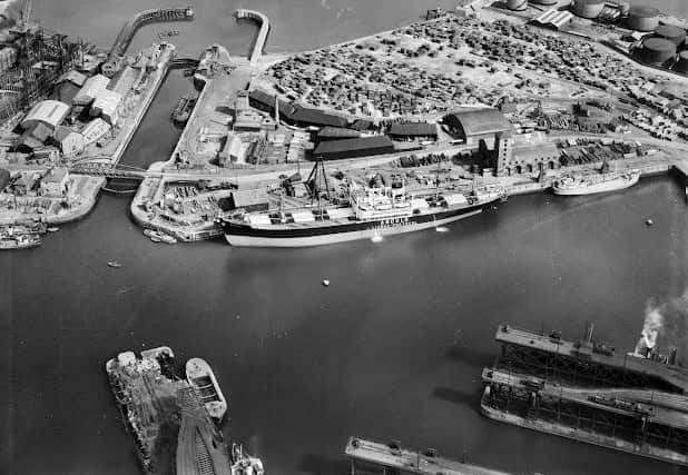
On Wearside, images show an aerial view of the Souter Lighthouse and ship building in Sunderland, with a picture of the MV Andulo, built by Bartram & Sons, probably taken to record its completion in May 1949.
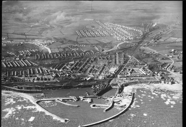
In County Durham, there’s an image of Seaham Harbour taken by an RAF reconnaissance aircraft in 1941.
Around 300,000 of the photographs are the work of Historic England’s Aerial Investigation and Mapping team.
Advertisement
Hide AdAdvertisement
Hide AdEstablished in 1967, the team takes photographs of England from the air to discover new archaeological sites, create archaeological maps and monitor the condition of historic sites across the country.
The remaining 100,000 images come from the Historic England Archive aerial photography collection, which numbers over two million images in total, and includes important historic photography, including interwar and post-war images from Aerofilms Ltd and The Royal Air Force.
Duncan Wilson, Chief Executive, Historic England, said: “I am delighted that our new online tool will allow people easy access to our wonderful collection of aerial images and to enjoy the historic photography that our team uses every day to unlock the mysteries of England’s past.”
Nigel Huddleston MP, Minister for Heritage said "What better way to discover our shared history than through this fascinating new online tool which offers a bird's eye view of our past. I can't wait to discover more about my local area and encourage everyone to explore the thousands of English sites from the last century."Over the coming years, Historic England aims to expand the platform, as more of the six million aerial images in Historic England Archive are digitised.
Advertisement
Hide AdAdvertisement
Hide AdThe Aerial Photography Explorer joins Historic England’s recently launched Aerial Archaeology Mapping Explorer to offer an unparalleled insight into England’s archaeology and the nation’s development.
