STORM ARWEN LATEST: Seafront warning issued for Sunderland as stunning photograph of Roker Pier captures the moment storm hits city
and live on Freeview channel 276
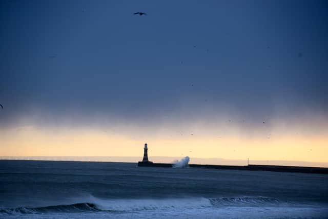
Captured just after 3pm on Friday, November 26, by Echo photographer Stu Norton, the image shows waves crashing into Roker Pier and storm clouds beginning to roll over Wearside.
As well as bringing cloudy weather and rain showers, Storm Arwen is bringing high winds that are anticipated to reach speeds of over 70mph.

Advertisement
Hide AdAdvertisement
Hide AdVideo footage captured from the promenade above Roker Beach shows a few brave walkers making their way along the sand as high winds can be heard over the audio.
On Friday evening, Sunderland City Council issued a warning to people to stay away from the seafront and to only go out if they have to.
It comes after the Met Office issued a red wind warning - the highest level of alert possible - which means there is a potential risk to life from flying debris.
The local authority said: “Gusts are expected to reach up to 60 mph across much of the North East, with the possibility of northerly winds up to 80mph along the coast early this evening and through until the early hours of Saturday.
Advertisement
Hide AdAdvertisement
Hide Ad"This is likely to lead to large and powerful waves with the potential for tidal surges and coastal flooding affecting along the seafront. A flood alert is in place for the Tyne and Wear coast tonight and into tomorrow morning.
"Winds are expected to remain very strong along the coast right through until Saturday morning before slowly moderating during the course of Saturday afternoon.
"Motorists should also take extra care on their journeys, especially when driving high sided vehicles or driving on higher and exposed routes.
"Sunderland City Council is working closely with the emergency services to prepare for and tackle any problems caused by the strong winds and flooding.”
Advertisement
Hide AdAdvertisement
Hide AdDespite the beauty of the image, Storm Arwen is bringing a host of issues along with it, as Met Office issues a red weather warning to be in affect from 3pm on Friday until 2am on Saturday, November 27, when it will be downgraded to amber.
The Met Office website says: “Exceptionally windy this evening, with potentially damaging gusts likely.
“Cold with outbreaks of rain, sleet and snow, heavy at times. Snow mostly over hills, but perhaps to some lower levels.
"Minimum temperature -1 °C."
Advertisement
Hide AdAdvertisement
Hide AdRail operator LNER has advised passengers to defer their travel if possible as Network Rail imposes emergency speed restrictions due to the extreme weather having an impact on the East Coast route.
Passengers are advised not to travel from today until the end of service on Sunday, November 28.